Puerto del Zamorano (Guadamanil River)
| Start Town | Altitude | Elevation Gain | Length | Gradient | Difficulty | Rating |
|---|---|---|---|---|---|---|
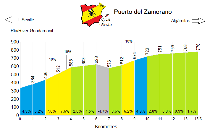
| Guadamanil River | 778m | 443m | 13.6 km | 3.3% | 241 | *** |
Climb Description
Puerto del Zamorano is a gentle climb in the southern part of the Sevilla region of Andalucia. Situated in the Sierra de Tablón mountains, it offers views of the large Sierra de Grazalema range in the distance.The climbs from the Guadamanil River is the toughest of the three main sides; with the average gradient hiding a short downhill section. Nevertheless, there is nothing too challenging here, and the average cyclist would be wise to include this as part of a longer route, rather than as a standalone climb.
Puerto del Zamorano is open throughout the year.
Roads & Traffic
The road surface is generally in good condition. There is not much traffic on the climb, but this is the busier of the three routes to Puerto del Zamorano.
Peñon de Guadamanil River
Puerto de las Palomas
Sierra de Lijar
Pedro Ruiz
Puerto del Viento
Cerro Becerrero
You may also be interested in the links below to some of the other tours that we currently run in Spain.
Alternative Routes
Puerto del Zamorano can also be climbed from Pruna and from the Algamitas.Nearby Climbs
Peñon de Guadamanil River
Puerto de las Palomas
Sierra de Lijar
Pedro Ruiz
Puerto del Viento
Cerro Becerrero
Cycling Holidays
We can arrange customized cycling holidays to the mountains of Malaga and the Sierra Grazalema; including the climb to Puerto del Zamorano. If you would be interested in this, please contact us to discuss the options and to put together an itinerary.You may also be interested in the links below to some of the other tours that we currently run in Spain.


 Spain
Spain


